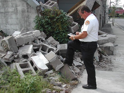
It’s hard to believe it’s been just over 10 years since Hurricane Katrina hit, displacing more than a million people throughout the Gulf Coast region. Roughly 80 percent of the City of New Orleans was flooded, with 70 percent of all occupied housing units damaged during the hurricane and flooding that followed. Parts of the City remained underwater for eight days until repairs to the levee system made it possible for water to start being pumped out.
I was living in Atlanta at the time and heard about the unprecedented devastation on the news. Little did I know that years later I would move across the country and join a company that was instrumental in the City of New Orleans’ efforts to get back on its feet and rebuild.
Coincidentally, about a year before Hurricane Katrina, the City’s Department of Safety and Permits implemented Accela Land Management to automate its building permit application, inspection and code enforcement processes, and gain centralized access to information concerning permitting, planning, licensing and enforcement activities.
Safety and Permits Director Mike Centineo, now retired, shares, “My department was responsible for damage assessments and determining the safety of structures before allowing citizens to reoccupy their homes. Because the system was web-based, we had access to all of our records and were the first department back and serving our community within weeks while much of the City was still under water.”
Accela gets the call
Mike’s home was one of the properties flooded, so he temporarily relocated to Dallas until it was safe for him to get back to work. A few weeks later, Mike reached out to Pete Ramos, his Accela account manager, for help. Soon after, a small but determined team – the majority of whom are still with Accela to this day – traveled to New Orleans to develop a solution that would extend Accela Land Management’s capabilities from routine building inspections to rapid damage assessment efforts.
Before they left for Louisiana, they reached out to Panasonic for help and secured 25 donated Panasonic Toughbooks loaded with Accela Wireless, the precursor to today’s Accela Mobile app. (Fun fact: their Panasonic rep was Barbara Taylor, who is now a senior account manager with Accela!)
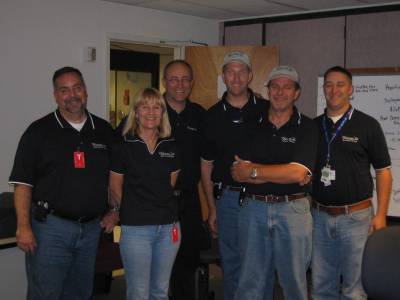
The original Hurricane Katrina crew (from left to right): Darrell Lewis, Betsy Higgins, Rich Morrey,
Larry Cooper, Paul Rose and Andrew D’Ottavio (not shown: photographer Pete Ramos).
A city in chaos
When Darrell Lewis, now Director of Strategic Initiatives with Accela, first arrived in New Orleans in mid-September, only one gate was open at the airport and armed guards greeted passengers on the tarmac. While navigating checkpoints and surface streets to reach the Emergency Operations Center (EOC), he “saw abandoned cars that had obviously been underwater and had floated to their current awkward and random locations. Buildings, signage, traffic signals, and power poles and power lines in the Central Business District showed significant damage, and navigating the streets to reach the EOC proved a bit harrowing.”
The team split up into groups, with some staying outside the city in a home they found advertised on Craigslist, and the rest staying aboard a ship docked on the Mississippi River that was reserved for emergency response and City staff. Each morning they traveled to the EOC, which had been established on the third floor of the Hyatt (windows had been blown out from the fourth floor up) adjacent to the Superdome.
Getting to work
Then they got to work configuring the solution to support FEMA reports for rapid damage assessments (with an XML version of FEMA’s disaster-inspection form) and allow for inspection results to be published online through Accela’s online portal, Citizen Access. Remembers Rich Morrey, now a Senior Technology Advisor with Accela, “We had about two weeks to get everything ready and test it out. Failure was not an option.”
“When the team came in they really pulled together and pulled the software together very quickly,” states Mike. “We needed to get the damage assessments to FEMA in order to document damage and show justification for request of federal assistance. FEMA wanted to do it with paper. They said we would need at least 4 people per team, 100 teams and 6 months to get the job done. I said, ‘I’ve reached out to a software company that I’ve been working with a couple years, and they’re going to come and deliver everything in a spreadsheet form — and we’re not going to do it with paper.’” This would be the first time FEMA received forms electronically.
——————-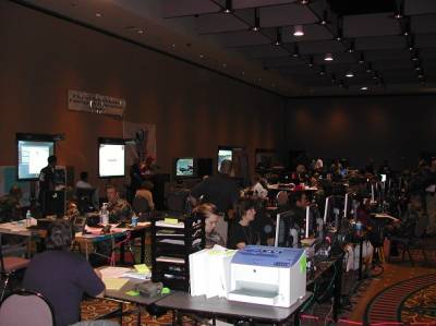
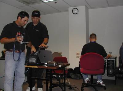
The makeshift Emergency Operations Center (left) and Pete Ramos, Rich Morrey and Andrew
D’Ottavio hard at work configuring the solution to handle rapid damage assessments (right).
Working with Cisco to create a wireless network
There was no wireless coverage in the City back in 2005, and it would prove instrumental in allowing inspectors to automatically upload data from their laptops when they reached a hot spot or returned to the office. The Toughbooks contained a GPS, which would be critical in helping inspectors identify their locations when they conducted inspections. With homes knocked off their foundations, street signs missing and all the debris (according to a news report, Hurricane Katrina created 15 years’ worth of refuse for the City in one day), it wasn’t always clear which property an inspector was looking at. With GPS, inspectors could match their location to the map, eliminating all doubt.
The following day was spent discussing options for deployment of a wireless network with Cisco representatives in order to support the use of Accela Wireless throughout the City of New Orleans. A wide range of options was considered, from attaching wireless points to the tops of street lights to mounting hot spots on trucks and moving them around the City. The team also had conversations with the Federal Aviation Administration to help get a solution in place.
Training the inspectors
Once the team had configured the new solution, it was time to train the inspectors. Only 17 of the City’s 43 inspectors came back to the City, but it was a dedicated group of people who were invested in restoring New Orleans. However, the task ahead was daunting: around 92,000 homes in the City needed review.
Andrew D’Ottavio, Paul Rose and Larry Cooper conducted initial training sessions with the inspectors. Darrell sat in on some of the training: “There was a wide range of levels of proficiency with computers and with the software, but the inspectors picked up the technology very quickly and were eager to get out in the field and begin the daunting task of inspecting a complete City’s worth of structures.” Some additional configuration of the solution and training would be required before the inspectors could hit the streets, but they had their first introduction to using the Panasonic Toughbooks with Accela Wireless.
——————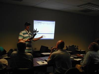
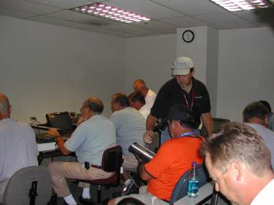
Andrew D’Ottavio (left) and Paul Rose (right) training inspectors on the newly configured solution.
The next day, the team got the Panasonic Toughbooks ready for the inspectors to take in the field and turned their attention to the next priority: getting Citizen Access ready for remote emergency permitting. With Mayor Nagin announcing plans to begin the repopulation of the City, inspections and permits would be required in order to make repairs that would then allow gas and electrical services to be restored. The Mayor was working to ensure that this process would be as efficient as possible for returning residents and business owners.
Hurricane Rita has other plans
On September 22nd, most of the team headed over to City Hall to get the inspectors started. Darrell attended the 0900 briefing at the EOC. “Hurricane Rita was definitely the topic of the day and, for the first time since we had been working in the EOC, everyone stopped what they were doing to listen to the weather briefing.”
So, on the day inspections were supposed to begin, the Safety and Permits inspectors were asked to evacuate as Hurricane Rita made its way towards the Gulf. Given what the City had just experienced a few weeks earlier, the decision was made to err on the side of caution. The team was able to get some of the last flights out of the City before they were grounded, and would reconvene the following week.
Hitting the streets
Inspections began approximately one month after the levees were breached. However, some unforeseen obstacles had to be addressed. “When they first went out, they came back pretty quickly,” recalls Rich. “They found the City still had some undesirable people. One group got chased back to their truck with people throwing rocks at them. There was also concern about them having computers in their hands. That’s when Mike called on the National Guard to come in to escort them.”
With 23 additional inspectors from California, and later additional assistance from the State, they worked seven days a week for 10 weeks. “As inspectors went out with devices and inspected properties,” recounts Darrell, “there were three levels: it could be repaired (yellow), was totally destroyed (red) or was habitable (green).” They could even circle an entire block that was completely underwater and red tag it to indicate it wasn’t safe. “That would show up on parcels on a map, so we could see the progress of them going through the whole City. It was amazing to me they were able to inspect so much of the City so rapidly and get to the point where they really understood which areas were the hardest hit.”
————–xx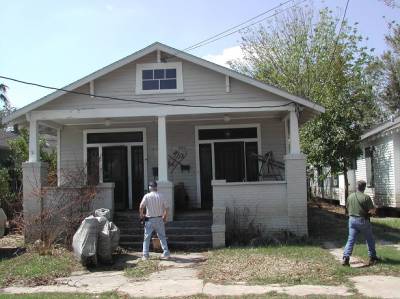
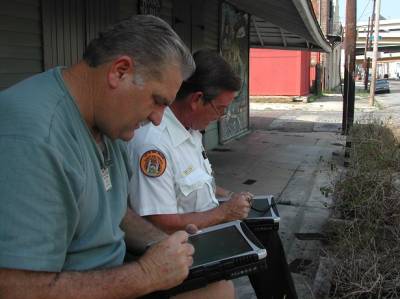
Inspectors going from structure to structure and completing damage assessments on Panasonic Toughbooks in the field.
“Because of the solution,” remembers Mike, “we were able to conduct the inspection of 125,000 structures in 10 1/2 weeks with only 40 teams of two people and submit our damage assessment to FEMA in digital format. We got it done in record time considering the circumstances. We had blocks of properties that were wiped out, no buildings. With the GIS system built into the software, we could identify the property in front of us and get the correct owner and address and then do the report.”
Coming home
The GIS mapping capability made it possible for City staff and the public to view real-time updates to the community online, and would be key in providing information to displaced residents about the status of their homes. Knowing which areas were green and habitable made it easy for government officials to make informed decisions in real time and bring the first wave of people home.
“If homeowners had damage to their homes,” explains Rich, “they had to have a City inspector make that assessment before they could have anything done with their insurance company. They could enter their address and view the inspection results that may have just been uploaded even two minutes before. They could then print and submit a form to their insurance company.”
Being prepared when disaster strikes
While Accela didn’t offer an out-of-the-box damage assessment solution back in August 2005, the flexibility of the platform demonstrates how quickly the team was able to modify it to meet the City of New Orleans’ needs after Hurricane Katrina. The team was able to get New Orleans automated and mobile, making Accela one of the first to bring mobile workforce capabilities to government.
FEMA was reluctant to accept forms electronically, but New Orleans didn’t have 400 inspectors and six months to spare before people could begin moving back to the City. Real-time mobile inspections sped up the entire process dramatically, providing information and transparency in a time of chaos. From hurricanes to earthquakes to tornadoes, having a disaster preparedness solution at the ready can help communities rebound more quickly when disaster strikes.
Looking back on that time, Pete remembers the experience fondly. Everyone agrees when he says, “It was a remarkable experience for all of us, and probably the single greatest thing we’ve done at Accela.” He continues, “You don’t wake up at a software company thinking you’re going to be in the heart of one of the biggest disasters in the country. The City is thriving again 10 years later, and Accela played a part in that.”


